Mississippi River Series- Part 2

After Hernando de Soto’s “discovery” of the Mississippi River in 1541, followed a period of exploration of the river by a number of explorers but it wasn’t until over three-hundred years later that a formal effort was implemented to manage the river. As noted in Part 1 of this series, de Soto crossed but didn’t explore the river. This painting is a depiction of de Soto’s Discovery of the Mississippi, oil on canvas by William H. Powell, 1848–53, in the rotunda of the U.S. Capitol, Washington, D.C. To me, that’s an indication of the significant importance of not only the discovery but of the Mississippi River itself and its role in the settlement and development of the United States.

Reported to be the first actual explorers of the river, albeit the upper reaches of the river, were the French traders Medard Chouart des Groseillers, Sier des Groseillers, and Pierre d’Espirit Sieur de Radisson. They conducted fur trading expeditions during the period 1654 and 1660 in the western Great Lakes that extended into the river. Chouart and Radisson are credited with the founding of the Hudson’s Bay Company. On one expedition, the indicated traders canoed into Green Bay and up Fox River to a point where they portaged two miles through marshes and oak plains to the Wisconsin River from which they entered the Mississippi River after an approximate 200-mile journey down the Wisconsin River. The route they forged, known as the Fox-Wisconsin Waterway, provided the major transportation route from the Great Lakes to the Mississippi River to the traders and explorers that followed them.

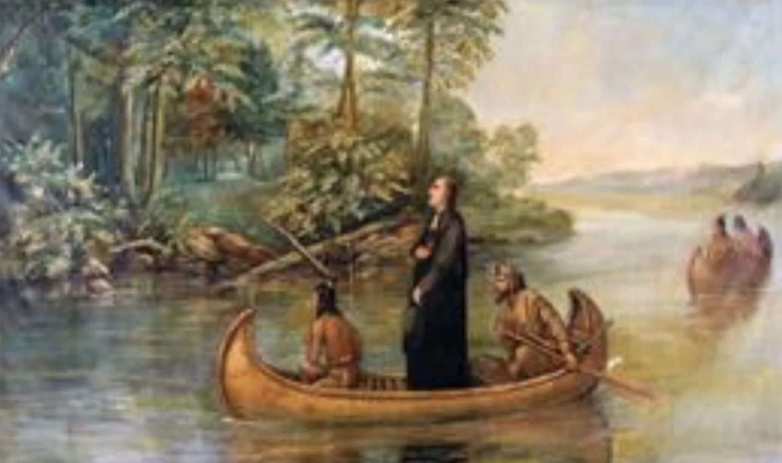
On May 27, 1673, Father Jacques Marquette, a 36-year-old Jesuit priest, and Louis Joliet, a 27- year-old philosophy student turned fur trader, launched on a four-month voyage from St. Ignace at the head of Lake Michigan to explore the Mississippi River. They followed the Fox-Wisconsin Waterway route established by Radisson and Groseilliers and explored as far south as the Arkansas River at which point they turned around believing that they had confirmed that the river drained into the Gulf of Mexico. On September 30, 1673, they concluded their voyage at St. Francis Xavier Mission near what is now Depere, Wisconsin. Their voyage helped to initiate the first non-Native American settlements in the interior of North America. Among other findings and observations, they concluded that the Native Americans living along the river were generally friendly and that the area along the river abounded with “extraordinary nature resources.” Shown is a modern version of the map prepared by Marquette that shows current state boundaries that didn’t exist at the time of the voyage. Radisson and Groseilliers are considered to be the first Europeans to “unquestionably” discover the Mississippi River. However, such a conclusion discounts the finding of the de Soto “discovery” made almost 130 years earlier. However, unlike Radisson and Groseilliers, de Soto and his expedition did not explore the river.
What factors account for the almost 140-year lapse in exploration of the Mississippi River after de Soto’s “discovery”? A definitive and accurate answer to this question is probably not possible. Was it the fact that de Soto’s “discovery” wasn’t widely publicized or even know outside of his expedition? Was it the fact that de Soto apparently showed little interest in the river given that the basic goal of his expedition was to find gold in the new world? It may have been because he was Spanish, and that French exploration of the new world was either nonexistent or in its very early stages. Even in its early stages, French exploration more or less began in what is now Canada and in areas generally remote from the Mississippi River.


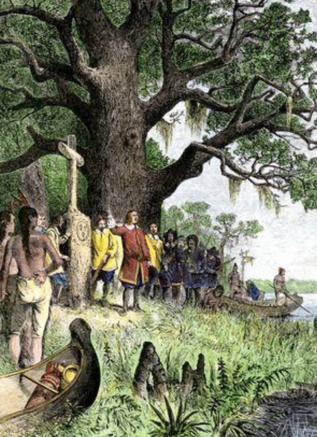
Following the Marquette and Joliet explorations of the river was Rene- Robert Cavelier, Sieur de La Salle, an explorer and fur trader. In early 1682, accompanied by Henri de Tonty, an Italian soldier of fortune, he canoed the Mississippi River below the Illinois River. His expedition proceeded to the mouth of the river, reaching it in April 1682, at which point he claimed the Mississippi River Basin for France naming it La Louisiane in honor Louis XIV. This event is portrayed, likely in a much more elaborate manner than the real event, in the 1870’s painting by Jean-Adolphe Bocquin. Below the Bocquin depiction is a less elaborate but unattributed depiction of the same event.
It is unclear at which “mouth of the river” that La Salle entered the Gulf of Mexico. At what is now referred to as the Head of Passes, he could have proceeded down one of several passes to the Gulf. In route to his return to Montreal, LaSalle, aided by Henri de Tonty, established a fort on the Illinois River whose purpose was to protect the region for France.
Subsequent to his arrival in Montreal, he returned to France only to mount another expedition to the North America and the Mississippi River on July 24, 1684. The purpose of this expedition was to establish a French colony near the Taensa Indians whose villages lined the shores of Lake St. Joseph in what is now Tensas Parish, Louisiana. His expedition included four ships and their crews and 400 colonists. What brave souls they must have been! One ship was lost to Spanish privateers in the West Indies during the voyage. Having failed to locate the “mouth of the river”, the expedition continued to proceed westward to as far as Matagorda Bay at which location the ships entered the bay on February 20, 1685. Unfortunately, one of the ships, Aimable, sank while entering Pass Cavallo at the mouth of the bay taking a number of the stores needed for the crew and colonists with it. This led the crew of that ship and several disenchanted colonists to return to France aboard the naval vessel, Joly, leaving La Salle with but one ship, his flagship La Belle.

Matagorda Bay is located on the Gulf coast approximately midway between present day Galveston and Corpus Christi. Looking at the map, as noted above, it’s obvious that the LaSalle expedition significantly overshot the multiple passes to the Mississippi River. A number of accounts of the expedition attributed this to an error in LaSalle’s determination of latitude at the mouth of the river at the time of his earlier expedition. However, latitude alone only defined the north-south location of the mouth of the river. A precise location could only be established by the east-west location of the mouth or its longitude. However, at that time, longitude could not be determined. To make matters worse, La Salle’s flagship La Belle was later wrecked on the bay’s peninsular during what was described as a squall, basically limiting the expedition to land-based operations.
The remains of the La Belle were discovered in 1995, excavated, reassembled, and are now displayed in the Bullock Museum Texas History Gallery. The exhibit includes the reassembled lower section of the hull plus cargo items. All told, 16 million artifacts were recovered including three bronze cannons, thousands of glass beads, bronze hawk bells, pottery, wine bottles of various shapes, and the skeleton of one crew member. Interestingly, the French Republic claimed and continues to retain title to the ship and its artifacts. In 2003, an agreement was signed that gave the ship and its artifacts to the Musee National de la Marine in Toulon, France, while granting day to day control of the ship to the TexasnHistorical Commission for 99 years. https://www.thestoryoftexas.com/la-belle/the-exhibit
The failure to locate the entrance to the Mississippi River via the Gulf motivated LaSalle to undertake a land-based expedition to locate the river. Surprisingly, he first travelled westerly and upon reaching the Rio Grande River realized his error and returned. He then organized two easterly expeditions only to be murdered on March 19, 1687, during the second expedition by an individual described as “a disenchanted follower.” The one colony that La Salle established near present day Victoria, Texas, lasted only about four years until its colonists were attacked and killed by members of a local Native American tribe. Five children of the colonists were effectively kidnapped and taken to live with the tribe. Further, reportedly being on La Salle’s land-based expedition at the time of the tribal attack, ten adult colonists of the original 180 at the settlement survived and returned to France.
There have been various explanations of why LaSalle missed the entrance to the Mississippi River among which are: an error in his latitude observation at the mouth of the river at the time he claimed the lands of the river basin for France; inaccurate measurements of latitude during his 1684 voyage due to lack of clear observations of the sun; and a damaged observation instrument. My conclusion is that latitude alone is at best only an approximate if not impossible way to locate a geographic position. Only when paired with the longitude of a location can you be assured of being able to locate the position. Unfortunately, at the time of La Salle’s expedition, the scientific measurement of longitude was not possible (see my brief on Longitude- https://maritimemuseumlouisiana.org/maritimeblog/longitude).

In late 1698, Pierre Le Moyne d ‘Iberville was commissioned by Jerome Phelypeaux, Comte de Pontchartrain, the French Minister of Naval Affairs, to lead an expedition of two ships the Badine and the Marin, to fortify the mouth of the Mississippi so as to secure the lands claimed for France by La Salle. Arriving on the northern Gulf Coast in January 1699, d ‘Iberville explored the coast before leaving his fleet anchored at Ship Island in the Mississippi Sound and setting out in open longboats and canoes to locate the mouth of the Mississippi River. The search party included d’Iberville’s brother, Bienville, about 50 crew members, and provisions for 20 days. Unlike La Salle, d ’Iberville located the mouth of the Mississippi River, albeit somewhat accidentally. By doing so, d ‘Iberville and his crew became the first European explorers to navigate the mouth of the Mississippi River from the Gulf of Mexico. That effectively opened the river to future exploration and use as a major transportation and trade route to inland America via the Gulf. Details about this expedition were described in an earlier brief- https://maritimemuseumlouisiana.org/maritimeblog/early-explorers-of-the-gulf-basin-and-the-mississippi-river-part-b
Here’s how d ’Iberville described his somewhat accidental discovery of the mouth of the river in the translated words of his Gulf Journal entry of March 1, 1699:
Traveling in deck less longboats carrying crew, stores, and canoes, the expedition encountered “wind north-northeast and heavy and the seas so high I could not keep to seaward, nor could I run for shore.” He then noted that he held “the southeast course for three hours in order to double (Note: meaning reach and round) a rocky point as night was coming on and the foul weather continuing , so that we could not endure without going to shore for the night lest we perish at sea. I stood for those rocks in order to run ashore by day and save my men and longboats. When drawing near the rocks to take shelter, I passed between two of the rocks in 12 ft. of water, the seas quite heavy. When I got close to the rocks, I found fresh water with a very strong current.”
At that point, d ‘Iberville realized that he had located one of the passes, possibly East Pass that is now designated North Pass, of the Mississippi River. Upon closer inspection, d ‘Iberville recognized that the rocks” he referred to “are logs petrified by the mud and changed into black rocks, which withstand the sea.” In reality, they were not logs at all but mud lumps. In his journal of his 1699-1700 voyage, d’Iberville noted: “All those rocks that are above water are nothing but mud hard enough to withstand the sea...”

After navigating the mouth into the main body of the river, d ‘Iberville and his crew continued rowing upstream, possibly sailing at times, to as far north as the confluence of Red River at times with guidance from Native Americans. Based on historical data, the U.S. National Park Service site lists the average river velocity at New Orleans in March as 3 mph, so progress upriver by manpower was not as easy task. Returning from their northernmost ascent of the river, and again guided by local Native American tribe members, the expedition descended and then exited the river (as indicated in his log, he named the river after himself- Riverie d ‘Iberville but later to be known as Bayou Manchac) and proceeded via the Amite River to and through two bodies of water that d‘Iberville named Lake Maurepas and Lake Pontchartrain, respectively. His expedition then crossed Lake Pontchartrain, made its way through the Rigolets to Lake Borgne and the Mississippi Sound where the remainder of his expedition awaited.
Referencing the diagram, the expedition started at the right-hand most arrow and proceeded clockwise to the upper arrow and then downstream to the intermediate arrow, before following an almost horizontal path to their starting point. Not that it’s overly important but I disagree with the path depicted for d’ Iberville in Lake Pontchartrain. I will provide an explanation for my disagreement with a separate addendum to this brief that will be published at a later date.
Before returning to France and having not found a suitable location for a fort in the Mississippi River delta, d ‘Iberville established Fort Maurepas on Biloxi Bay, leaving Seur de Sauvole as commandant, his brother De Bienville as deputy commandant, and Le Vasseur Russouelle major in charge, with a garrison of “70 men and six cabin boys.”
D’Iberville led two subsequent expeditions to the northern Gulf Coast and the Mississippi River in 1699-1700 and 1701-1702. Neither of these explorations made any particularly important new discoveries but may be the subject of a later brief.

Location of the headwaters to the Mississippi River is attributed to Henry Rowe Schoolcraft, a federal agent to the indigenous people, who in 1832 began his exploration of a body of water that he named Lake Itasca, Itasca meaning “true head”. His expedition was aided by indigenous people he lived with having married an Ojibwe woman. Details about his travels are lacking but were likely aided by his involvement in the earlier Cass Expedition.

Two expeditions preceded the Schoolcraft expedition. This first was led by Lieutenant Zebulon Montgomery Pike, Jr., shortly after the Louisiana Purchase in 1805-06. At the request of President Thomas Jefferson, Pike lead an expedition starting at St. Anthony on the Mississippi River and proceeding upstream only to be forced to halt his progress somewhere between Leech Lake and Sandy Lake by particularly harsh winter weather. At the termination of the expedition, he was within 80 miles of the headwaters.

The second earlier expedition was led in 1820 by Lewis Cass who at the time was Governor of the Michigan Territory. Cass was authorized by the then U. S. Secretary of War John C. Calhoun to undertake the expedition whose purpose was multi-faceted but included searching for the source of the Mississippi River. The expedition encompassed 42 men including soldiers, scientists, Native Americans, traders, and Canadians. Included in that group was Henry Schoolcraft, mineralogist and geologist, who was to later become the first American to locate the source of the river. Despite their efforts, the Cass Expedition failed to locate the source of the river.
While not an expedition to explore the Mississippi River, President Thomas Jefferson authorized a military party to explore the south and west of the Louisiana Purchase. Beginning in June 1806, this expedition, led by Lieutenant Zebulon Pike, Jr., encompassed exploration of the following Mississippi River tributaries: Red River, Arkansas River, and Missouri River. The expedition was more or less contemporaneous with the more well-known Lewis and Clark Expedition. Pike was promoted to captain while leading this expedition.
Yet another expedition, the Dunbar and Hunter Expedition (also known as the Grand Expedition) explored the lower portion of the Louisiana Purchase. Led by William Dunbar and Dr. George Hunter, the expedition was tasked to explore parts of Mississippi and Missouri. Authorized by President Thomas Jefferson in 1804, the party travelled the Ouachita River and parts of Arkansas as well as Louisiana, Mississippi, and Missouri.
The next Mississippi River Brief will focus on the 19th Century studies of the river by Charles Ellet, James B. Eads, and A. A. Humphreys and their recommendations for the management
and control of the river.
Click here to read Part 1.
Sources
Iberville’s Gulf Journal. Translated by Richebourg Gaillard McWilliams, The University of Alabama Press, Tuscaloosa, 1981.
https://en.wikipedia.org/wiki/Lewis_Cass_expedition
https://en.wikipedia.org/wiki/Dunbar_and_Hunter_Expedition
https://en.wikipedia.org/wiki/Pike_Expedition
https://en.wikipedia.org/wiki/Hernando_de_Soto
https://en.wikipedia.org/wiki/Henry_Schoolcraft
https://en.wikipedia.org/wiki/Ren%C3%A9-Robert_Cavelier,_Sieur_de_La_Salle
https://en.wikipedia.org/wiki/M%C3%A9dard_des_Groseilliers
https://en.wikipedia.org/wiki/Pierre-Esprit_Radisson
http://scihi.org/jolliet-marquette-expedition-upper-mississippi/