Battle of Lake Borgne
December 14, 1814, marked the date of a battle at Lake Borgne between the forces of the British Royal Navy and the US Navy in what was the American Southern Theatre of the War of 1812. The principal significance of this battle is that it paved the way for the British to deploy ground forces at the western end of Lake Borgne in advance of their planned attack of New Orleans and, ultimately, to face the US forces under the command of General Andrew Jackson in what became known as the Battle of New Orleans.
Rather than a conventional inland lake, Lake Borgne is actually a lagoon of the Gulf of Mexico located in southwestern Louisiana. “This 1759 map based on the 1720 de la Tour survey shows Lake Borgne separated from the Gulf of Mexico by "Low and Marshy Meadows" (wetlands).” However, coastal erosion and marsh deterioration over the intervening 100 years or so rendered Lake Borgne directly accessible via the Mississippi Sound from the Gulf as depicted in the map to the right. Lake Pontchartrain is accessible via the Rigolets located at the eastern end of Lake Borgne and the Chef Menteur Pass located at the north central shore of the Lake.


The Battle of Lake Borgne was preceded by the British defeat at Fort Bowyer in September of 1814. The Fort, an “earthen and stockade fortification”, was located at Mobile Point near the mouth of Mobile Bay. Fort Bowyer was ultimately replaced by Fort Morgan, a much more substantial masonry structure. According to Caville, the attack on Fort Bowyer “was intended to be the first step in the landing operation for the attack on New Orleans.” Basically, the original British plan was to land troops at Mobile and have them march overland via the Old Spanish Trail to New Orleans. Having failed at this first step in their plan, the British investigated navigating Bayou LaFourche as an alternate route to New Orleans but abandoned that plan for lack of a guide. Yet another alternate was considered- move their fleet to Lake Borgne, locate and pass through the Rigolets to Lake Pontchartrain and proceed to and through Bayou St. John to New Orleans. After the Battle of Lake Borgne described in the following pages, it was reported that the British learned of a more direct route to New Orleans from local fishermen via Bayou Bienvenue and the Villere Canal. The bayou is located on the western shore of Lake Borgne. The attack on New Orleans via this approach was to be led by Major General Sir Edward Parkman (shown above) who was in command of a British expeditionary force of about 8,000 troops.

It’s difficult to see on the map below but the Bayou is located in the upper left-hand corner of the map. It should be noted that the water course angled across the map is the Mississippi River Gulf Outlet that didn’t exist until mid-20th century. Once through the waterways, a challenge in itself, it is apparent that the land over which the troops had to cross was swampy, likely slowing their progress to New Orleans. That circumstance favored preparations by the defenders of New Orleans under the command of Andrew Jackson.

Being warned of the advance of the British fleet towards Louisiana, Commodore Patterson of the New Orleans Squadron began assembling a fleet of gunboats and tenders to undertake a reconnaissance mission to determine facts about the British fleet. As the British fleet was observed congregating at an anchorage in the Mississippi Sound in the area of Ship and Cat Islands, Patterson dispatched Lieutenant Thomas ap Catesby Jones (above) and a small flotilla to carry out the reconnaissance mission to Lake Borgne. Sent under his command were “five Jeffersonian gunboats, the schooner USS Sea Horse with Sailing-Master Johnson commanding, and two sloops, USS Alligator and USS Tickler.” Jones was ordered not to engage the British fleet.


Responsible for navigating the route from their current position in Pensacola to planned attack on New Orleans was the British Commander-in-Chief of the North American Station, Vice Admiral Sir Alexander Cochrane (shown here). He ordered the British vessels, HMS Seahorse, Armide and Sophie, to proceed from Pensacola to an anchorage at Ship Island off the coast of Mississippi. At that point, the operational plan for the British forces was to pass through the Rigolets into Lake Pontchartrain and make their way to Bayou St. John to gain access for their attack on New Orleans. Given observations as well as some cannon fire from US naval vessels, the British naval forces apparently concluded that engagement with US forces would be needed to achieve their objectives. Recognizing that the British ships of the line could not navigate the shallow waters of Lake Borgne, Cochrane decided to deploy all the rowboats in his fleet, a total of forty-two launches and barges, to attack the US Naval fleet. He placed this flotilla under the command of Commander Nicholas Lockyer of Sophie. Personnel-wise, the British force amounted to some 1,000 or so sailors and Royal Marines. Given the total number of British forces suggests that there could have been a force of approximately 20-25 men on each of its 42 launches and barges. US Naval personnel deployed in each of its five gunboats were estimated to range from 36 to 45 for a total of 182 to 225 men. Thus, personnel-wise, US Naval forces were outnumbered more than 4 to one. Armament-wise, the US Naval Forces were outgunned as well.

Violating the order to simply observe but not engage the British Naval Forces, the US Naval forces initially engaged the British Naval forces near their Cat Island anchorage. However, upon observing the size of the British force chose to reverse course to a more advantageous position. The USS Seahorse was directed to proceed to Bay St. Louis by Jones to either protect or destroy the stores located there while the remainder of the US fleet continued westward towards Lake Borgne. As the British forces followed and proceeded westward towards their objective of the Rigolets, they engaged the USS Seahorse. The superior firepower of the British fleet ultimately forced the crew of the USS Seahorse to scuttle her to avoid her capture. Adverse current slowed the westerly progress of the US fleet and forced them to take a stand at a position between Point Claire and Malheureux Island. The figure below depicts the locations of the respective naval fleets- five US Jeffersonian gunboats versus forty-two British barges more or less at the initiation of the actual naval engagement which was reported to been initiated at 10:29 a.m.

As depicted in the illustration, Lockyer organized the British fleet into three divisions, each under the command of an officer, one of whom was Lockyer himself. The British sailors had been rowing some 36 hours at which time they reached a position near St. Jose Island. In advance of the main battle of the engagement, the British were able to capture the USS Alligator, thus she was not a factor in the battle to follow.
After allowing his forces to rest and have breakfast, Lockyer ordered the British forces to row towards the five US gunboats arrayed and anchored across the strait between Point Claire and Malheureux Island. As the British barges approached the American fleet, they were met with a barrage of gunfire that killed an indeterminate number of British sailors and marines. But given their overwhelming number, as physical proximity of the British vessels with the US gunboats was achieved, British forces were able to board and take control of the US vessels. The guns of one of the captured US gunboats were turned against the other gunboats, thus contributing to the capture of the remaining gunboats. It was reported that the engagement concluded at 1230 pm which meant that the total period of the engagement was approximately 2 hours. During that 2-hour period, the US had 6 sailors killed and 35 wounded, six vessels captured, and one vessel scuttled. The British forces suffered 17 killed and 77 wounded and one rowboat sunk. Not to dimmish the death of British sailors and marines, the Battle of Lake Borgne must be judged to be a significant British victory not just in terms of the naval battle itself but in achieving its larger objective of securing a landing site for troops on the western shore of Lake Borgne in preparation for an attack on New Orleans. Presumably, the circumstances of the battle and what was learned from local fishermen in the area, lead Cochrane to conclude that gaining access to New Orleans via Bayou Beinvenue rather than Bayou St. John was strategically and tactically preferable.

As noted on the caption of the painting (oil by T. Hornbrook) above, the Lake Borgne battle was considered an action in the Battle of New Orleans not a separate engagement. Discussion of the Battle of New Orleans, that took place on January 8, 1815, is judged to be outside the scope of the maritime history of the Basin but can be found at this source. It should be noted that the commander of the British ground forces that attacked the US forces at New Orleans commanded by General Andrew Jackson, Major General Sir Edward Parkman, was killed in the attack.
Both Lockyer and Jones were seriously wounded in the Battle of Lake Borgne but survived. Jones was taken prisoner along with the surviving US sailors and transported to a camp in the Caribbean in January 1815. For his success, Lockyer was promoted by the British to Post Captain. The five Jeffersonian gunboats of the US fleet were renamed and placed into service as part of the British fleet.
The Treaty of Ghent between the two warring parties, signed on December 24, 1814, didn’t immediately end the War of 1812 but initiated the ratification process. In Britain, the Treaty was quickly ratified and signed into law on December 30, 1814. In the US, the Treaty wasn’t ratified by the US Senate until February 16, 1815, and signed by President Madison the following evening thus completing the ratification process needed to fully enact the Treaty and end the war. This action led to the repatriation of the US prisoners taken at the Battle of Lake Borgne. Upon his repatriation, Jones was decorated for bravery. It should be noted that word of the signing of the Treaty did not reach the United States in time to prevent the Battle of New Orleans, but it should be noted that the war was not over until both parties had ratified the Treaty.
On important and, perhaps, underappreciated consequence of the Battle of Lake Borgne is the fact that it delayed the advance of the British ground forces thus allowing Andrew Jackson valuable time to better prepare his defenses of the City of New Orleans.
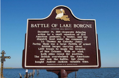
The historical marker memorializing the Battle of Lake Borgne is located on Yscloskey Highway (State Highway 46) at Shell Beach, Louisiana, St. Bernard Parish.
Sources
Battle of Lake Borgne, Wikipedia Battle of Lake Borgne - Wikipedia
Battle of New Orleans, Wikipedia Battle of New Orleans - Wikipedia
Alexander Cochrane, Wikipedia Alexander Cochrane - Wikipedia
Thomas ap Catesby Jones, Wikipedia Thomas ap Catesby Jones - Wikipedia
Acknowledgement
The significant contributions of Dr. Samantha Cavell, Assistant Professor of Military History, Southeastern Louisiana University, to the content of this brief are gratefully acknowledged. Dr. Cavell also provided the following listing of reference sources concerning the Battle of Lake Borgne.
The Greatest Fury. The Battle of New Orleans and the Rebirth of America. William C. Davis. Dutton Caliber, Penguin Random House Company, Canada, 2020.
Historical Memoir of the War in West Florida and Louisiana in 1814-15. Arsene LaCarriere Latour. Edited by Gene A. Smith. University Press of Florida, First Edition, 1999.
“The Battle of Lake Borgne,” S. A. Cavell. The Battle of New Orleans Reconsidered. Xlibris Publishing Company, United States, 2014